Kouvola
Kouvola had 78,386 residents at the end of 2024. Median disposable income of adults was €25,380 in 2024, in line with the regional level. 29% of households rented and 70% owned their home. The population has fallen by 8.7% since 2015.
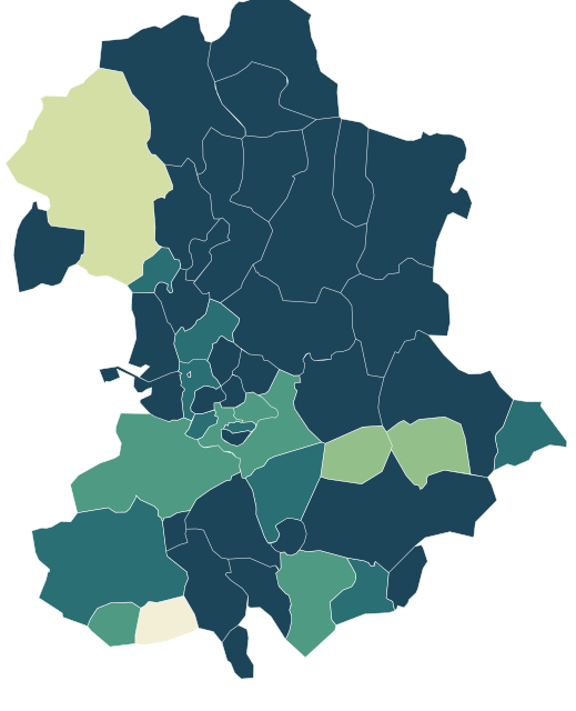
Sources: Statistics Finland, Paavo open data by postal code area 2026 (CC BY 4.0) · Statistics Finland, municipal and regional boundaries 2026 (CC BY 4.0) · © OpenStreetMap contributors (ODbL)
All 48 postcode areas.
Colour shows where each one sits among the others in the table, from lowest to highest.
| Postcode area | Residents | Median income | Renting | Owning | 65+ | Avg. age | Unemployment | Green 500 m | Services 15 min |
|---|---|---|---|---|---|---|---|---|---|
| 45100 Kouvola Keskus | 8,995 | €24,989 | 40% | 59% | 36% | 51 | 12.8% | 19% | 216 |
| 45120 Kotkankallio-Vahteronmäki | 3,729 | €28,900 | 15% | 84% | 26% | 45 | 8.2% | 23% | 209 |
| 45130 Korjala-Kaunisnurmi | 1,675 | €23,376 | 51% | 48% | 25% | 45 | 16.9% | 26% | 162 |
| 45150 Kankaronmäki-Eskolanmäki | 4,705 | €23,343 | 42% | 57% | 30% | 47 | 17.3% | 37% | 95 |
| 45160 Lehtomäki | 5,109 | €23,501 | 41% | 58% | 27% | 46 | 17.6% | 30% | 47 |
| 45200 Tornionmäki | 5,785 | €23,869 | 41% | 58% | 29% | 47 | 16.0% | 18% | 80 |
| 45330 Harju | 269 | €27,468 | 2% | 97% | 28% | 50 | 9.6% | 68% | 1 |
| 45360 Kukkuramäki | 3,563 | €29,201 | 21% | 79% | 22% | 44 | 8.8% | 39% | 25 |
| 45370 Valkeala kk | 2,498 | €27,373 | 29% | 71% | 30% | 48 | 9.0% | 46% | 25 |
| 45410 Utti | 758 | €27,280 | 8% | 89% | 29% | 49 | 8.9% | 55% | 20 |
| 45460 Savero | 179 | €26,151 | 4% | 91% | 25% | 47 | 12.3% | 12% | 2 |
| 45610 Koria | 4,565 | €26,886 | 22% | 77% | 27% | 46 | 10.1% | 21% | 55 |
| 45700 Kuusankoski Keskus | 8,351 | €25,241 | 34% | 65% | 37% | 52 | 15.7% | 30% | 96 |
| 45720 Kotiharju-Puhjonmäki | 2,475 | €27,618 | 20% | 79% | 23% | 46 | 14.9% | 31% | 38 |
| 45740 Maunuksela | 2,574 | €25,806 | 19% | 81% | 32% | 49 | 12.6% | 61% | 80 |
| 45750 Kuusankosken Sairaala-alue | 62 | €15,012 | 100% | 0% | 11% | 34 | 50.0% | 37% | 106 |
| 45810 Pilkanmaa | 1,334 | €27,161 | 7% | 92% | 26% | 47 | 12.5% | 54% | 21 |
| 45910 Voikkaa | 2,414 | €23,752 | 24% | 74% | 28% | 48 | 18.9% | 24% | 29 |
| 45940 Oravala | 248 | €24,976 | 2% | 96% | 36% | 55 | 12.9% | 40% | 1 |
| 46110 Tuohikotti | 334 | €24,227 | 8% | 88% | 36% | 53 | 13.3% | 55% | 5 |
| 46140 Vekaranjärvi | 127 | €23,974 | 41% | 57% | 35% | 52 | 10.8% | 48% | 16 |
| 46230 Aro | 451 | €26,456 | 4% | 92% | 26% | 48 | 9.3% | 88% | 4 |
| 46400 Kaipiainen | 403 | €25,763 | 10% | 88% | 32% | 52 | 11.5% | 53% | 3 |
| 46430 Tirva-Inkerilä | 251 | €28,747 | 2% | 95% | 24% | 50 | 10.6% | 74% | 4 |
| 46450 Enäjärvi | 141 | €25,053 | 7% | 91% | 32% | 53 | 10.3% | 11% | 2 |
| 46570 Saaramaa | 34 | €24,628 | – | – | 47% | 59 | 6.2% | 25% | 3 |
| 46710 Sippola | 668 | €25,377 | 15% | 84% | 34% | 51 | 12.2% | 46% | 11 |
| 46730 Ruotila | 116 | €24,883 | 0% | 98% | 46% | 55 | 6.8% | 43% | 0 |
| 46750 Liikkala | 247 | €25,610 | 5% | 94% | 31% | 50 | 15.0% | 27% | 3 |
| 46800 Myllykoski | 4,259 | €25,324 | 26% | 73% | 32% | 50 | 17.7% | 29% | 47 |
| 46810 Ummeljoki | 1,282 | €26,150 | 8% | 90% | 29% | 50 | 15.3% | 38% | 43 |
| 46860 Anjalankoski Keskus | 490 | €24,457 | 37% | 61% | 29% | 50 | 21.4% | 36% | 8 |
| 46900 Inkeroinen | 3,186 | €25,152 | 27% | 72% | 36% | 52 | 17.6% | 22% | 36 |
| 46910 Anjala | 1,674 | €26,872 | 19% | 80% | 30% | 49 | 14.4% | 40% | 25 |
| 46950 Ahvio | 48 | €22,601 | – | – | 38% | 58 | 15.4% | 78% | 1 |
| 46960 Muhniemi | 305 | €26,931 | 2% | 97% | 31% | 51 | 8.2% | 57% | 3 |
| 47110 Löytty | 65 | €29,610 | 0% | 97% | 23% | 51 | 7.7% | 32% | 1 |
| 47150 Raussila | 122 | €27,225 | 6% | 93% | 32% | 50 | 9.8% | 2% | 2 |
| 47200 Elimäki kk | 2,083 | €23,842 | 22% | 77% | 37% | 52 | 12.8% | 29% | 24 |
| 47260 Ratula | 108 | €22,165 | 0% | 94% | 29% | 50 | 11.5% | 18% | 3 |
| 47650 Kimola | 173 | €24,892 | 4% | 97% | 30% | 50 | 8.0% | 49% | 2 |
| 47710 Jaala kk | 953 | €23,585 | 16% | 83% | 37% | 53 | 12.2% | 8% | 20 |
| 47760 Huhdasjärvi | 98 | €21,956 | 4% | 91% | 52% | 63 | 18.9% | 68% | 3 |
| 47810 Selänpää | 247 | €25,681 | 5% | 95% | 32% | 53 | 9.4% | 36% | 3 |
| 47830 Hasula | 91 | €24,063 | 9% | 91% | 31% | 52 | 21.2% | 42% | 3 |
| 47850 Verla | 132 | €27,564 | 3% | 93% | 42% | 56 | 9.3% | 61% | 7 |
| 47900 Vuohijärvi | 205 | €21,592 | 25% | 75% | 54% | 62 | 21.6% | 66% | 4 |
| 52920 Voikoski | 118 | €22,612 | 0% | 92% | 46% | 57 | 15.2% | 88% | 1 |
Sources: Statistics Finland, Paavo open data by postal code area 2026 (CC BY 4.0) · © OpenStreetMap contributors (ODbL)
People.
Age at the end of 2024, next to the figure for Kymenlaakso.
Main activity
Population at the end of each year
Source: Statistics Finland, Paavo open data by postal code area 2026 (CC BY 4.0)
Income and education.
Disposable income in 2024 and education at the end of 2024.
Education of adults
Income is the disposable money income of residents aged 18 and over in 2024: taxable and tax-free income minus taxes and contributions. The median is the middle value, so a few high earners do not pull it up.
Source: Statistics Finland, Paavo open data by postal code area 2026 (CC BY 4.0)
Homes.
42,468 households and 48,580 homes at the end of 2024.
Households by tenure
Households
Household groups overlap: young one-person households, for example, are also counted as one-person households.
Statistics Finland withholds a figure when fewer than 30 people are behind it (fewer than 10 for workplaces). Missing figures are shown as a dash and never estimated.
Source: Statistics Finland, Paavo open data by postal code area 2026 (CC BY 4.0)
Everyday life.
81 everyday shops and services within a 15-minute walk; 31% green space within 500 metres.
Services and green space are measured from each postcode area’s service centre: the point inside the area with the most shops and services within 500 metres. Municipal and regional figures are averages weighted by population.
Source: © OpenStreetMap contributors (ODbL)
Postcode areas.
Other municipalities in Kymenlaakso.