Gulen
Gulen had 2,301 residents on 1 January 2026. Median household income after tax was NOK 682,200 in 2024, 3% below the county level. 30% of households rented their home. The population is almost unchanged since 2020.
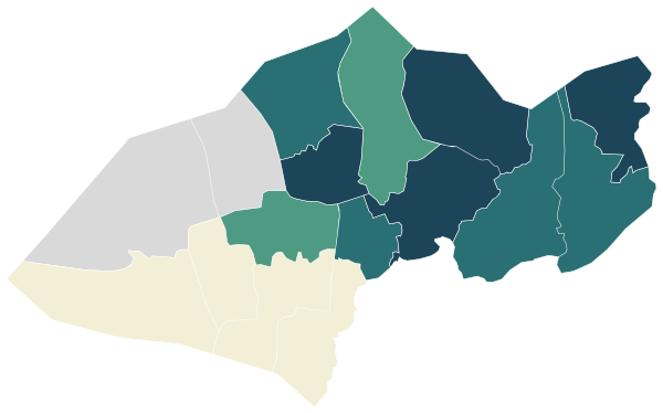
Sources: Statistics Norway (SSB), StatBank (CC BY 4.0) · © Norwegian Mapping Authority, basic statistical units (CC BY 4.0) · © OpenStreetMap contributors (ODbL)
All 14 neighbourhoods.
Colour shows where each one sits among the others in the table, from lowest to highest.
| Neighbourhood | Residents | 67+ | Under 16 | Per km² | Green 500 m | Services 15 min |
|---|---|---|---|---|---|---|
| Asheim | 66 | 29% | 15% | 1 | 22% | 0 |
| Austgulen | 56 | 43% | 5% | 1 | 71% | 0 |
| Brandanger | 40 | 23% | 15% | 1 | 17% | 0 |
| Brekke | 277 | 17% | 16% | 4 | 27% | 7 |
| Byrknes | 329 | 21% | 14% | 13 | 1% | 6 |
| Dalsøyra | 183 | 25% | 18% | 8 | 25% | 7 |
| Eidsbotnen | 236 | 12% | 20% | 8 | 1% | 2 |
| Eivindvik | 422 | 21% | 19% | 14 | 34% | 9 |
| Fivelsdal | 106 | 27% | 12% | 3 | 0% | 0 |
| Hjartholm | 115 | 29% | 18% | 3 | 37% | 2 |
| Mjømna | 127 | 26% | 7% | 5 | 0% | 0 |
| Nordgulen | 161 | 20% | 14% | 3 | 22% | 0 |
| Oppedal | 85 | 21% | 19% | 3 | 80% | 0 |
| Sygnefest | 41 | 32% | 0% | 2 | 22% | 1 |
Sources: Statistics Norway (SSB), StatBank (CC BY 4.0) · © OpenStreetMap contributors (ODbL)
People.
Age on 1 January 2026, next to the figure for Vestland.
Population on 1 January
Source: Statistics Norway (SSB), StatBank (CC BY 4.0)
Income and work.
Income in 2024, employment in late 2025 and education in 2025.
Education, aged 16 and over
Income after tax is a household’s total income minus tax and negative transfers, for private households in 2024. The median is the middle value, so a few high incomes do not pull it up.
Source: Statistics Norway (SSB), StatBank (CC BY 4.0)
Homes.
1,333 homes in 2026.
Households by tenure, 2025
Homes by type of building
Source: Statistics Norway (SSB), StatBank (CC BY 4.0)
Everyday life.
4 everyday shops and services within a 15-minute walk; 22% green space within 500 metres.
Services and green space are measured from each area’s service centre: the point inside it with the most shops and services within 500 metres. District, municipal and county figures are averages weighted by population.
Source: © OpenStreetMap contributors (ODbL)
Around here.
Photographs taken near Gulen, shared on Wikimedia Commons under free licences.

i


i

Other municipalities in Vestland.