DE · EN

Nuremberg

Nuremberg had 522,383 residents at the 2022 census. Average net rent of €8.20/m² was 7% below the state average. 28.1% of homes were owner-occupied, and the average age was 43.0.
Independent city · Code 09564 · Zensus 2022 · Updated 24 October 2026
522,383residentscensus, 15 May 2022
€8.20/m²net rentaverage
28.1%owner-occupiedof homes
17%green within 500 maverage
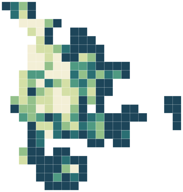
Nuremberg · one-kilometre grid
Map of Nuremberg: Share of land within 500 m that is green space
0%30%+
Share of land within 500 m that is green space

Sources: Federal and State Statistical Offices of Germany, 2022 census grid results (open data, with attribution) · © GeoBasis-DE / BKG (2023), administrative areas VG250 as of 15 May 2022, dl-de/by-2-0 · © OpenStreetMap contributors (ODbL)

People.

Age and households at the 2022 census, next to the figure for Bavaria.

16%
aged under 18
15%
aged 18–29
28%
aged 30–49
20%
aged 65 and over
43.0
years, average age
1.9
people per household

Source: Federal and State Statistical Offices of Germany, 2022 census grid results (open data, with attribution)

Homes.

72,913 residential buildings.

€8.20/m²
average net rent
28.1%
of homes owner-occupied
3.1%
of homes empty
50.1 m²
living space per resident

When residential buildings were built

before 19197%
1919–194913%
1950–195915%
1960–196917%
1970–197914%
1980–19899%
1990–19996%
2000–20096%
2010–20153%
2016 or later3%

Main type of heating

Central heating50%
District heating28%
Single-storey heating15%
Block heating1%
Room stoves5%

Net rent comes from the 2022 census (reference date 15 May 2022) and covers every rented home, including long-standing tenancies, so it is usually lower than the asking rents in new listings.

Figures for municipalities, districts and states are built up from the census 100-metre grid cells, with rents weighted by the number of homes. Vacancy and owner-occupation rates come from the one-kilometre grid, as they are mostly withheld in the 100-metre cells.

Source: Federal and State Statistical Offices of Germany, 2022 census grid results (open data, with attribution)

Everyday life.

268 everyday shops and services within a 15-minute walk, for the average resident; 17% green space within 500 metres.

Supermarkets and convenience shops36
Bakeries44
Pharmacies11
Doctors28
Dentists15
Cafés and bars242
Restaurants215
Parks21
Playgrounds13
Sports pitches12
Gyms and sports centres10
Libraries4
Day nurseries15
Bus stops49
Tram and light-rail stops22
Railway stations7
147schoolsOpenStreetMap
334nurseries and kindergartensOpenStreetMap
2,783residents per km²density
187.7km²area

Source: © OpenStreetMap contributors (ODbL). Within one kilometre.

Crime.

Offences recorded by the police in 2025 (Nuremberg), next to the state average.

7,028offences per 100,000 residentsstate: 3,869
37,213recorded offences2025
67%clearance ratestate: 68%
OffenceCasesper 100,000state, per 100,000
Violent crime1,744329163
Common assault3,148595380
Robbery2514720
Domestic burglary3156029
All theft13,5732,5631,076
Bicycle theft1,726326165
Car theft841612
Theft from vehicles84616081
Shoplifting4,291810288
Pickpocketing4478423
Fraud3,932743444
Criminal damage3,807719450
Street crime6,3251,195639

Police crime statistics count offences that became known to the police and were fully processed by them, by place of offence. The rate relates them to the resident population, so cities with many commuters, visitors and shops show higher rates. Offences against residence and asylum law and drug offences are not shown here; drug offences mostly reflect how actively the police carry out checks.

Source: PKS Bundeskriminalamt (Federal Criminal Police Office), reporting year 2025, version 1.1 (Data licence Germany – attribution 2.0)

Around here.

Photographs taken near Nuremberg, shared on Wikimedia Commons under free licences.

Karolinenstraße 27-29 Nürnberg
i
Karolinenstraße 27-29 Nürnberg
Photo: Aarp65 · CC BY-SA 3.0
View on Wikimedia Commons
Samstags nach 8
i
Samstags nach 8
Photo: jorabo · CC BY 3.0
View on Wikimedia Commons
Nürnberg - Karolinenstraße - 007
i
Nürnberg - Karolinenstraße - 007
Photo: DALIBRI · CC BY-SA 4.0
View on Wikimedia Commons

Other districts in Bavaria.


Aichach-Friedberg districtAltötting districtAmbergAmberg-Sulzbach districtAnsbachAnsbach districtAschaffenburgAschaffenburg districtAugsburgAugsburg districtBad Kissingen districtBad Tölz-Wolfratshausen districtBambergBamberg districtBayreuthBayreuth districtBerchtesgadener Land districtCham districtCoburgCoburg districtDachau districtDeggendorf districtDillingen a.d. Donau districtDingolfing-Landau districtDonau-Ries districtEbersberg districtEichstätt districtErding districtErlangenErlangen-Höchstadt districtForchheim districtFreising districtFreyung-Grafenau districtFürstenfeldbruck districtFürthFürth districtGarmisch-Partenkirchen districtGünzburg districtHaßberge districtHofHof districtIngolstadtKaufbeurenKelheim districtKempten (Allgäu)Kitzingen districtKronach districtKulmbach districtLandsberg am Lech districtLandshutLandshut districtLichtenfels districtLindau (Bodensee) districtMain-Spessart districtMemmingenMiesbach districtMiltenberg districtMühldorf a. Inn districtMunichMunich districtNeu-Ulm districtNeuburg-Schrobenhausen districtNeumarkt i.d. OPf. districtNeustadt a.d. Aisch-Bad Windsheim districtNeustadt a.d. Waldnaab districtNürnberger Land districtOberallgäu districtOstallgäu districtPassauPassau districtPfaffenhofen a.d. Ilm districtRegen districtRegensburgRegensburg districtRhön-Grabfeld districtRosenheimRosenheim districtRoth districtRottal-Inn districtSchwabachSchwandorf districtSchweinfurtSchweinfurt districtStarnberg districtStraubingStraubing-Bogen districtTirschenreuth districtTraunstein districtUnterallgäu districtWeiden i.d. OPf.Weilheim-Schongau districtWeißenburg-Gunzenhausen districtWunsiedel i. Fichtelgebirge districtWürzburgWürzburg district