Eure-et-Loir
Eure-et-Loir has 432,950 residents in 365 communes. Over five years, homes sold for a median €1,900/m², from €1,180/m² in Vald'Yerre to €2,720/m² in Épernon among communes of more than 2,000 people. 66% of households own their main home.
Four maps of Eure-et-Loir.
Each commune is coloured by its value; every map uses the same colour scale, from lowest to highest. Grey: not published.
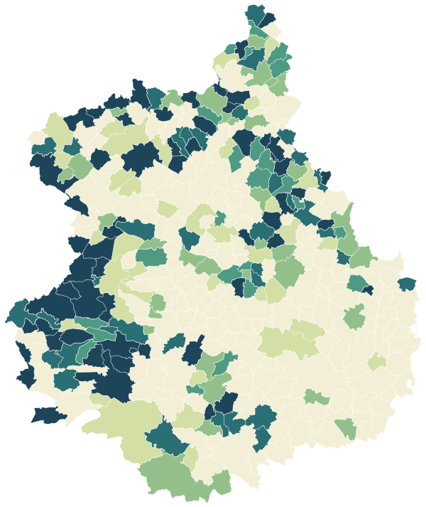
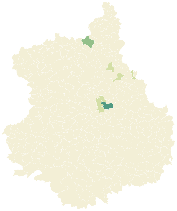
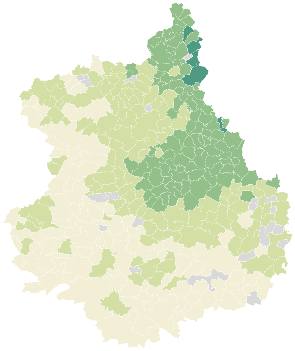
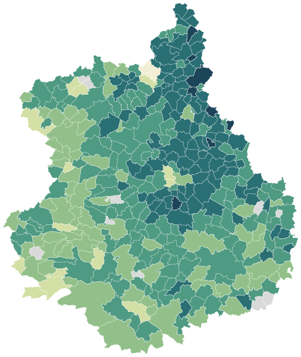
Sources: IGN and Insee, IRIS boundaries and Admin Express 2024 (Open Licence 2.0) · DGFiP property sales (DVF), data.gouv.fr statistics (Open Licence 2.0) · Insee, Filosofi 2021 income data (Open Licence 2.0) · © OpenStreetMap contributors (ODbL)
The 40 communes with more than 2,000 people.
Colour shows where each commune sits among the others in the table, from lowest to highest.
| Commune | Residents | Price per m² | Living standard | Home owners | Aged 75+ | Unemployment | Green 500 m | Services 15 min |
|---|---|---|---|---|---|---|---|---|
| Abondant | 2,446 | €2,350/m² | €26,810 | 79% | 10% | 7.7% | 1% | 16 |
| Anet | 2,708 | €2,350/m² | €24,220 | 67% | 16% | 9.1% | 39% | 23 |
| Arcisses | 2,209 | €1,500/m² | €23,190 | 79% | 13% | 8.1% | 42% | 13 |
| Auneau-Bleury-Saint-Symphorien | 6,354 | €2,260/m² | €23,530 | 65% | 8% | 8.3% | 12% | 31 |
| Bonneval | 4,890 | €1,560/m² | €22,400 | 65% | 14% | 11.9% | 15% | 40 |
| Brou | 3,245 | €1,390/m² | €20,500 | 58% | 22% | 15.2% | 5% | 51 |
| Bû | 2,093 | €2,570/m² | €26,320 | 79% | 6% | 8.1% | 14% | 21 |
| Champhol | 3,674 | €2,450/m² | €26,790 | 77% | 8% | 5.8% | 14% | 40 |
| Chartres | 37,990 | €2,490/m² | €22,770 | 41% | 12% | 12.1% | 8% | 148 |
| Châteaudun | 12,898 | €1,310/m² | €19,300 | 48% | 14% | 19.9% | 4% | 30 |
| Châteauneuf-en-Thymerais | 2,632 | €1,730/m² | €21,400 | 51% | 15% | 10.8% | 5% | 27 |
| Cloyes-les-Trois-Rivières | 5,601 | €1,240/m² | €22,660 | 76% | 15% | 9.6% | 11% | 30 |
| Courville-sur-Eure | 2,802 | €1,920/m² | €22,300 | 53% | 12% | 9.6% | 3% | 28 |
| Dreux | 31,205 | €1,770/m² | €18,250 | 41% | 8% | 20.7% | 15% | 105 |
| Gallardon | 3,537 | €2,180/m² | €24,170 | 67% | 9% | 7.5% | 4% | 36 |
| Hanches | 2,710 | €2,560/m² | €27,330 | 81% | 7% | 7.1% | 5% | 17 |
| Illiers-Combray | 3,228 | €1,450/m² | €21,440 | 62% | 16% | 11.1% | 4% | 26 |
| Janville-en-Beauce | 2,482 | €1,650/m² | €22,530 | 69% | 13% | 9.0% | 1% | 18 |
| La Loupe | 3,230 | €1,420/m² | €19,340 | 48% | 17% | 16.0% | 7% | 45 |
| Le Coudray | 4,063 | €2,590/m² | €26,390 | 57% | 9% | 8.2% | 27% | 56 |
| Les Villages Vovéens | 3,977 | €1,750/m² | €21,970 | 68% | 11% | 11.0% | 5% | 26 |
| Lucé | 15,658 | €2,200/m² | €19,390 | 33% | 10% | 16.1% | 1% | 80 |
| Luisant | 6,818 | €2,450/m² | €25,250 | 59% | 13% | 9.4% | 20% | 60 |
| Lèves | 5,701 | €2,380/m² | €25,170 | 63% | 8% | 8.7% | 32% | 65 |
| Maintenon | 4,532 | €2,440/m² | €24,930 | 67% | 11% | 11.1% | 15% | 67 |
| Mainvilliers | 10,950 | €2,280/m² | €20,670 | 43% | 8% | 18.1% | 1% | 91 |
| Nogent-le-Roi | 4,023 | €1,990/m² | €22,780 | 55% | 11% | 12.9% | 21% | 69 |
| Nogent-le-Rotrou | 9,305 | €1,320/m² | €21,140 | 54% | 17% | 13.1% | 29% | 28 |
| Pierres | 2,792 | €2,440/m² | €26,290 | 71% | 11% | 8.8% | 23% | 55 |
| Saint-Denis-Lanneray | 2,095 | €1,500/m² | €23,320 | 84% | 16% | 7.8% | 24% | 10 |
| Saint-Georges-sur-Eure | 2,728 | €2,200/m² | €25,440 | 80% | 12% | 5.1% | 10% | 17 |
| Saint-Lubin-des-Joncherets | 4,129 | €1,750/m² | €21,300 | 62% | 11% | 15.8% | 23% | 42 |
| Saint-Prest | 2,119 | €2,310/m² | €28,640 | 88% | 8% | 6.4% | 24% | 17 |
| Saint-Rémy-sur-Avre | 4,065 | €1,890/m² | €21,610 | 63% | 7% | 15.0% | 13% | 33 |
| Senonches | 3,013 | €1,380/m² | €21,450 | 63% | 18% | 14.4% | 3% | 36 |
| Toury | 2,620 | €1,720/m² | €22,110 | 67% | 10% | 7.3% | 4% | 18 |
| Tremblay-les-Villages | 2,208 | €1,770/m² | €24,660 | 84% | 5% | 8.8% | 1% | 13 |
| Vald'Yerre | 3,608 | €1,180/m² | €21,350 | 80% | 15% | 12.0% | 6% | 9 |
| Vernouillet | 12,491 | €1,940/m² | €19,570 | 56% | 11% | 19.0% | 21% | 39 |
| Épernon | 5,509 | €2,720/m² | €23,440 | 43% | 8% | 11.6% | 26% | 68 |
Sources: Insee, 2022 population census (sub-municipal files, Open Licence 2.0) · DGFiP property sales (DVF), data.gouv.fr statistics (Open Licence 2.0) · Insee, Filosofi 2021 income data (Open Licence 2.0) · © OpenStreetMap contributors (ODbL)
People.
432,950 residents and 190,295 households at the 2022 census, next to the département figure.
Source: Insee, 2022 population census (sub-municipal files, Open Licence 2.0)
Homes.
221,767 homes, 86% of them main residences, with 4.4 rooms on average.
When main homes were built
Source: Insee, 2022 population census (sub-municipal files, Open Licence 2.0)
Property prices.
28,220 house and flat sales over five years.
Median prices from sales published in France’s Demandes de valeurs foncières (DVF) over ten half-years, for sales of a single property. Individual sales are not shown. A median is only given where there were at least ten sales.
Source: DGFiP property sales (DVF), data.gouv.fr statistics (Open Licence 2.0)
Income and work.
Work and qualifications at the 2022 census.
Sources: Insee, 2022 population census (sub-municipal files, Open Licence 2.0)
Health, shops and services.
Facilities and services in Eure-et-Loir on 1 January 2025, from Insee’s permanent database of facilities.
Insee’s permanent database of facilities lists the shops, services and health professionals present in each commune on 1 January. Health professionals in private practice are counted one by one; several may work at the same address.
Source: Insee, permanent database of facilities 2025 (Open Licence 2.0)
Natural and industrial hazards.
Share of the département’s 365 communes exposed to each major hazard, and natural-disaster declarations since 1982.
Natural-disaster declarations by type
A natural-disaster declaration (arrêté CatNat) lets insurers pay out for the damage. The count reflects past events, not a forecast of future risk. The list of hazards comes from each département’s major-risk file; a prevention plan in force limits building in exposed zones.
Source: Géorisques, GASPAR database (Open Licence 2.0), as of 5 October 2026