Loire
Loire has 772,041 residents in 323 communes. Over five years, homes sold for a median €1,600/m², from €950/m² in La Ricamarie to €2,900/m² in L'Étrat among communes of more than 2,000 people. 59% of households own their main home.
Four maps of Loire.
Each commune is coloured by its value; every map uses the same colour scale, from lowest to highest. Grey: not published.
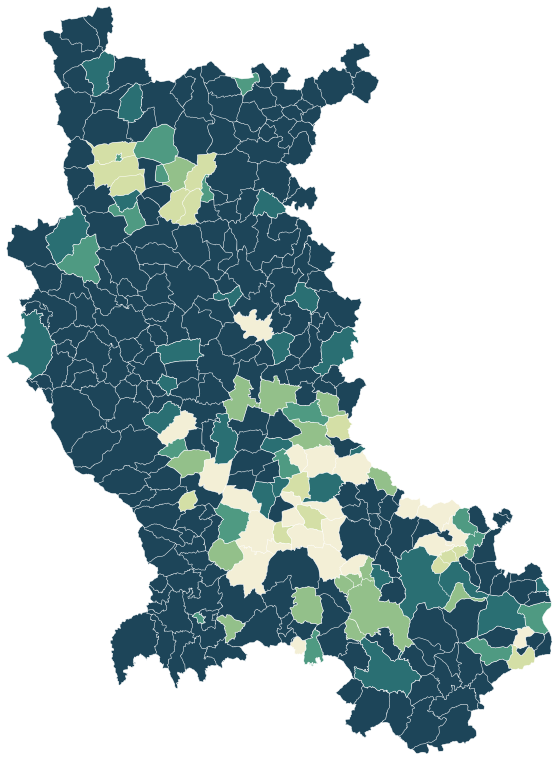
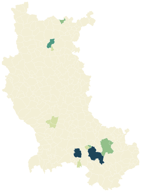
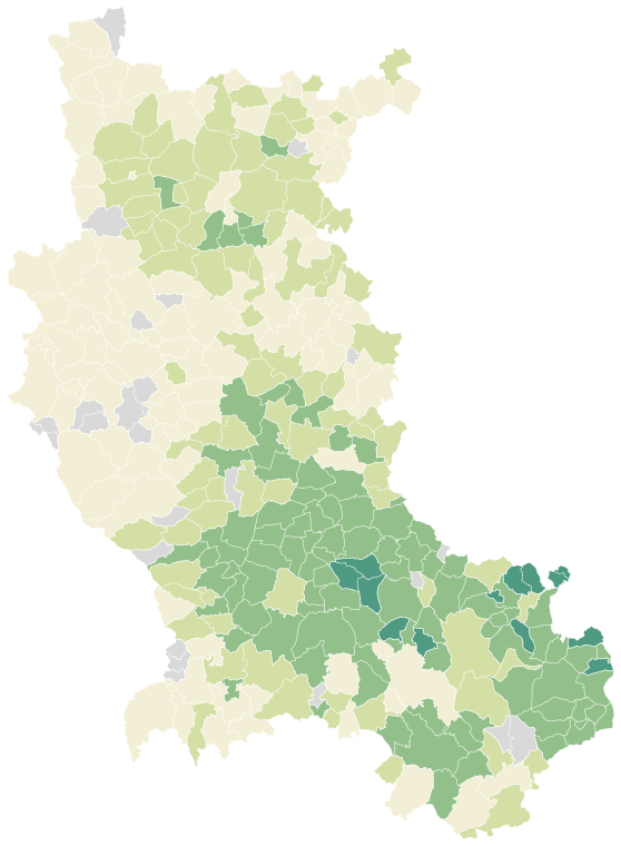
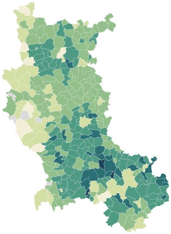
Sources: IGN and Insee, IRIS boundaries and Admin Express 2024 (Open Licence 2.0) · DGFiP property sales (DVF), data.gouv.fr statistics (Open Licence 2.0) · Insee, Filosofi 2021 income data (Open Licence 2.0) · © OpenStreetMap contributors (ODbL)
The 58 communes with more than 2,000 people.
Colour shows where each commune sits among the others in the table, from lowest to highest.
| Commune | Residents | Price per m² | Living standard | Home owners | Aged 75+ | Unemployment | Green 500 m | Services 15 min |
|---|---|---|---|---|---|---|---|---|
| Andrézieux-Bouthéon | 10,312 | €2,680/m² | €22,200 | 54% | 10% | 10.1% | 1% | 36 |
| Balbigny | 2,848 | €1,770/m² | €21,020 | 64% | 14% | 10.5% | 4% | 20 |
| Bellegarde-en-Forez | 2,004 | €2,120/m² | €23,510 | 76% | 12% | 5.2% | 5% | 18 |
| Bonson | 4,478 | €2,460/m² | €23,020 | 68% | 10% | 8.7% | 1% | 17 |
| Bourg-Argental | 2,920 | €1,470/m² | €21,940 | 62% | 16% | 8.2% | 32% | 35 |
| Boën-sur-Lignon | 3,017 | €1,290/m² | €19,810 | 56% | 20% | 14.7% | 27% | 51 |
| Champdieu | 2,035 | €1,920/m² | €23,940 | 73% | 11% | 8.1% | 12% | 17 |
| Charlieu | 3,703 | €1,440/m² | €20,420 | 36% | 17% | 13.5% | 16% | 120 |
| Chavanay | 2,886 | €2,240/m² | €24,760 | 74% | 9% | 7.3% | 19% | 15 |
| Chazelles-sur-Lyon | 5,507 | €2,110/m² | €21,810 | 58% | 14% | 6.9% | 1% | 48 |
| Commelle-Vernay | 3,041 | €2,020/m² | €24,710 | 90% | 11% | 5.5% | 6% | 12 |
| Feurs | 8,370 | €1,960/m² | €20,980 | 52% | 17% | 11.0% | 15% | 29 |
| Firminy | 17,128 | €1,160/m² | €19,020 | 47% | 15% | 19.5% | 22% | 77 |
| Fraisses | 3,825 | €1,780/m² | €23,530 | 68% | 11% | 7.0% | 5% | 56 |
| Genilac | 3,821 | €2,400/m² | €25,220 | 83% | 8% | 5.7% | 4% | 13 |
| L'Horme | 4,868 | €2,390/m² | €21,200 | 54% | 11% | 15.1% | 8% | 105 |
| L'Étrat | 2,820 | €2,900/m² | €27,460 | 64% | 13% | 7.8% | 3% | 37 |
| La Fouillouse | 4,643 | €2,370/m² | €26,800 | 69% | 13% | 5.6% | 0% | 22 |
| La Grand-Croix | 4,951 | €2,170/m² | €21,280 | 58% | 10% | 11.1% | 7% | 57 |
| La Ricamarie | 8,162 | €950/m² | €17,020 | 45% | 9% | 21.7% | 13% | 44 |
| La Talaudière | 7,103 | €2,780/m² | €23,700 | 58% | 17% | 7.8% | 26% | 34 |
| Le Chambon-Feugerolles | 12,307 | €1,510/m² | €18,610 | 47% | 12% | 16.9% | 61% | 47 |
| Le Coteau | 6,893 | €1,420/m² | €20,710 | 47% | 20% | 11.6% | 20% | 96 |
| Lorette | 4,896 | €2,400/m² | €21,450 | 59% | 12% | 11.0% | 7% | 41 |
| Mably | 7,246 | €1,880/m² | €21,680 | 68% | 16% | 11.7% | 45% | 38 |
| Montbrison | 16,098 | €2,070/m² | €22,210 | 52% | 12% | 11.2% | 30% | 87 |
| Montrond-les-Bains | 5,655 | €2,440/m² | €23,730 | 59% | 14% | 5.9% | 15% | 56 |
| Panissières | 2,882 | €1,480/m² | €21,930 | 71% | 17% | 7.8% | 26% | 35 |
| Perreux | 2,105 | €1,810/m² | €24,820 | 80% | 12% | 5.7% | 41% | 9 |
| Pouilly-les-Nonains | 2,165 | €2,120/m² | €23,440 | 83% | 10% | 6.8% | 50% | 14 |
| Pouilly-sous-Charlieu | 2,584 | €1,500/m² | €21,400 | 68% | 14% | 10.7% | 30% | 49 |
| Pélussin | 3,665 | €2,060/m² | €23,860 | 64% | 13% | 8.3% | 29% | 52 |
| Renaison | 3,220 | €1,990/m² | €23,970 | 76% | 13% | 8.3% | 6% | 37 |
| Riorges | 11,034 | €1,710/m² | €22,360 | 68% | 14% | 11.9% | 14% | 50 |
| Rive-de-Gier | 15,457 | €1,740/m² | €19,320 | 44% | 10% | 16.4% | 20% | 47 |
| Roanne | 35,364 | €1,310/m² | €18,930 | 38% | 14% | 16.9% | 8% | 140 |
| Roche-la-Molière | 9,853 | €2,080/m² | €22,590 | 60% | 11% | 10.4% | 45% | 26 |
| Saint-Chamond | 35,586 | €1,560/m² | €20,330 | 48% | 12% | 14.1% | 27% | 130 |
| Saint-Cyprien | 2,428 | €2,520/m² | €24,580 | 74% | 8% | 7.2% | 5% | 23 |
| Saint-Galmier | 5,848 | €2,460/m² | €26,680 | 65% | 13% | 5.2% | 26% | 4 |
| Saint-Genest-Lerpt | 6,182 | €2,400/m² | €24,970 | 62% | 12% | 8.0% | 39% | 35 |
| Saint-Genest-Malifaux | 2,912 | €2,220/m² | €25,430 | 70% | 11% | 6.5% | 26% | 28 |
| Saint-Héand | 3,684 | €2,230/m² | €25,650 | 74% | 14% | 5.3% | 32% | 22 |
| Saint-Jean-Bonnefonds | 6,594 | €2,190/m² | €23,950 | 63% | 9% | 9.1% | 45% | 47 |
| Saint-Just-Saint-Rambert | 15,579 | €2,670/m² | €26,190 | 69% | 12% | 6.3% | 35% | 26 |
| Saint-Marcellin-en-Forez | 5,088 | €2,420/m² | €23,780 | 71% | 9% | 6.0% | 2% | 29 |
| Saint-Martin-la-Plaine | 3,768 | €2,780/m² | €25,630 | 78% | 9% | 6.5% | 20% | 20 |
| Saint-Paul-en-Jarez | 4,758 | €2,370/m² | €23,630 | 63% | 9% | 10.0% | 25% | 25 |
| Saint-Priest-en-Jarez | 6,318 | €2,470/m² | €25,120 | 52% | 14% | 8.5% | 12% | 112 |
| Saint-Romain-le-Puy | 4,121 | €2,200/m² | €23,500 | 71% | 9% | 6.7% | 17% | 24 |
| Saint-Étienne | 172,569 | €1,260/m² | €19,010 | 40% | 11% | 19.1% | 14% | 278 |
| Savigneux | 3,489 | €2,420/m² | €23,520 | 69% | 11% | 6.3% | 4% | 68 |
| Sorbiers | 8,071 | €2,610/m² | €25,720 | 73% | 11% | 7.7% | 30% | 28 |
| Sury-le-Comtal | 6,651 | €1,890/m² | €21,570 | 69% | 7% | 9.1% | 1% | 39 |
| Unieux | 8,495 | €1,900/m² | €22,060 | 63% | 10% | 11.9% | 33% | 38 |
| Veauche | 8,984 | €2,720/m² | €24,910 | 74% | 12% | 6.0% | 7% | 21 |
| Villars | 7,705 | €1,330/m² | €23,540 | 70% | 12% | 8.3% | 13% | 79 |
| Villerest | 5,175 | €1,980/m² | €24,840 | 82% | 13% | 7.3% | 9% | 19 |
Sources: Insee, 2022 population census (sub-municipal files, Open Licence 2.0) · DGFiP property sales (DVF), data.gouv.fr statistics (Open Licence 2.0) · Insee, Filosofi 2021 income data (Open Licence 2.0) · © OpenStreetMap contributors (ODbL)
People.
772,041 residents and 351,390 households at the 2022 census, next to the département figure.
Source: Insee, 2022 population census (sub-municipal files, Open Licence 2.0)
Homes.
408,131 homes, 86% of them main residences, with 4.1 rooms on average.
When main homes were built
Source: Insee, 2022 population census (sub-municipal files, Open Licence 2.0)
Property prices.
50,318 house and flat sales over five years.
Median prices from sales published in France’s Demandes de valeurs foncières (DVF) over ten half-years, for sales of a single property. Individual sales are not shown. A median is only given where there were at least ten sales.
Source: DGFiP property sales (DVF), data.gouv.fr statistics (Open Licence 2.0)
Income and work.
Work and qualifications at the 2022 census.
Sources: Insee, 2022 population census (sub-municipal files, Open Licence 2.0)
Health, shops and services.
Facilities and services in Loire on 1 January 2025, from Insee’s permanent database of facilities.
Insee’s permanent database of facilities lists the shops, services and health professionals present in each commune on 1 January. Health professionals in private practice are counted one by one; several may work at the same address.
Source: Insee, permanent database of facilities 2025 (Open Licence 2.0)
Natural and industrial hazards.
Share of the département’s 323 communes exposed to each major hazard, and natural-disaster declarations since 1982.
Natural-disaster declarations by type
A natural-disaster declaration (arrêté CatNat) lets insurers pay out for the damage. The count reflects past events, not a forecast of future risk. The list of hazards comes from each département’s major-risk file; a prevention plan in force limits building in exposed zones.
Source: Géorisques, GASPAR database (Open Licence 2.0), as of 5 October 2026