Saint-Jean-de-Boiseau
Saint-Jean-de-Boiseau has 6,024 residents and 2,588 homes, 88% of them houses. Homes sold for a median €3,050/m² over five years, 4% below the département figure. The median living standard is €24,230 a year. For the average resident, 16 everyday shops and services are within a 15-minute walk.
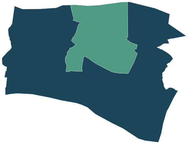
Sources: IGN and Insee, IRIS boundaries and Admin Express 2024 (Open Licence 2.0) · © OpenStreetMap contributors (ODbL) · Insee, Filosofi 2021 income data (Open Licence 2.0)
All 2 IRIS neighbourhoods.
IRIS are Insee’s statistical neighbourhoods of about 2,000 people each. Colour shows where each one sits among the others.
| Neighbourhood | Residents | Living standard | Home owners | Social housing | Aged 75+ | Unemployment | Green 500 m | Services 15 min |
|---|---|---|---|---|---|---|---|---|
| Centre Ville-Nord Rigaudière | 1,873 | €23,330 | 68% | 25% | 12% | 9.2% | 17% | 17 |
| Télindière-Surchaud-Prunière-Boiseau Sud | 4,151 | €24,710 | 80% | 10% | 7% | 6.9% | 63% | 15 |
Sources: Insee, 2022 population census (sub-municipal files, Open Licence 2.0) · Insee, Filosofi 2021 income data (Open Licence 2.0) · © OpenStreetMap contributors (ODbL)
People.
6,024 residents and 2,468 households at the 2022 census, next to the département figure.
Source: Insee, 2022 population census (sub-municipal files, Open Licence 2.0)
Homes.
2,588 homes, 95% of them main residences, with 4.6 rooms on average.
When main homes were built
Source: Insee, 2022 population census (sub-municipal files, Open Licence 2.0)
Property prices.
336 house and flat sales over five years.
Median prices from sales published in France’s Demandes de valeurs foncières (DVF) over ten half-years, for sales of a single property. Individual sales are not shown. A median is only given where there were at least ten sales.
Source: DGFiP property sales (DVF), data.gouv.fr statistics (Open Licence 2.0)
Income and work.
Median living standard of €24,230 a year in 2021.
Living standard is a household’s disposable income after taxes and benefits, divided by its consumption units. Half of residents live on less than the median. Income on its own says nothing about what a neighbourhood is like to live in.
Sources: Insee, Filosofi 2021 income data (Open Licence 2.0) · Insee, 2022 population census (sub-municipal files, Open Licence 2.0)
Safety.
Offences recorded in 2025, with the rate per 1,000 residents and the change from 2024.
| Indicator | 2025 | Rate | Change |
|---|---|---|---|
| Burglaries of homes | 8 | 3.1 per 1,000 | +60% |
| Thefts from people without violence | 15 | 2.5 per 1,000 | −12% |
| Armed robberies | 0 | 0.0 per 1,000 | – |
| Physical violence outside the family | 5 | 0.8 per 1,000 | −17% |
| Domestic physical violence | 31 | 5.1 per 1,000 | +72% |
| Sexual violence | 7 | 1.2 per 1,000 | – |
| Vehicle thefts | 9 | 1.5 per 1,000 | −47% |
| Thefts from vehicles | 19 | 3.1 per 1,000 | +58% |
| Deliberate damage and vandalism | 32 | 5.3 per 1,000 | +3% |
| Fraud and payment card fraud | 31 | 5.1 per 1,000 | +7% |
These figures count offences recorded by the police and gendarmerie, not how safe a place feels, and not every offence is reported. Rates are per 1,000 residents (per 1,000 homes for burglaries): where many people visit but few live, as in town centres and shopping areas, they are naturally higher. Small counts are not published.
Source: Ministry of the Interior (SSMSI), recorded crime by municipality 2024–2025 (Open Licence 2.0)
Everyday life.
What is within one kilometre of the town hall. For the average resident, 6 public transport stops are within 800 m, and the nearest rail or tram station is 3.0 km away.
Source: © OpenStreetMap contributors (ODbL)
Health, shops and services.
Facilities and services in Saint-Jean-de-Boiseau on 1 January 2025, from Insee’s permanent database of facilities.
Insee’s permanent database of facilities lists the shops, services and health professionals present in each commune on 1 January. Health professionals in private practice are counted one by one; several may work at the same address.
Source: Insee, permanent database of facilities 2025 (Open Licence 2.0)
Natural and industrial hazards.
Major hazards the State lists for Saint-Jean-de-Boiseau, prevention plans in force and natural-disaster declarations since 1982.
Natural-disaster declarations by type
A natural-disaster declaration (arrêté CatNat) lets insurers pay out for the damage. The count reflects past events, not a forecast of future risk. The list of hazards comes from each département’s major-risk file; a prevention plan in force limits building in exposed zones.
Source: Géorisques, GASPAR database (Open Licence 2.0), as of 5 October 2026
Schools.
3 primary and nursery schools, 0 collèges and 0 lycées are open here, 2 of them state schools.
Source: Ministry of Education, school directory (Open Licence 2.0). Admission depends on catchment rules and each school’s own policy.
Nearby communes.
The communes in the département whose town halls are closest.